Hacklebarney State Park At A Glance...
- Todays Sunrise: 6:00 am, Sunset: 7:52 pm
- New Jersey Skylands Region Morris County
About Hacklebarney State Park
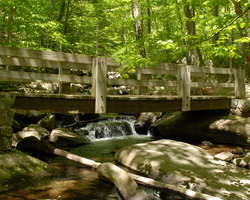
Today Hacklebarney is a favorite place for avid anglers, hikers and picnickers, yet in the 19th century the park was a mined iron ore site. The gushing river against the grey boulders and dark green hemlocks creates a majestic beauty in any season.
Three rare and endangered plant species exist within the park: American ginseng, leatherwood and Virginia pennywort. Over a hundred bird species and wildlife such as black bear, woodchuck, deer and fox live in the park.
Hacklebarney is a hiking only park, no bikes are allowed on any trails.
-
Activities:
- Fishing
- Hiking
- Hunting
-
Jogging / Running
Trail Running
Amenities:- Bathrooms
- Parking Lot(s)
- Picnic / Sitting Area
- Benches
- Picnic tables
- Playground
Trails:- Rugged / Rocky
Park Type:- State Parks
- Playground
Rules/Regulations:- Biking *NOT Permitted*
- Equestrian / Horseback *NOT* Allowe
Contact / Location
Trail & Path Info
Our preferred route when visiting the park is to follow the outermost trails, going "clockwise" from the main lot...
We leave the parking lot along the main trail, taking the first left, down the stairs onto the "Upper Trail" (red). This brings you past some picnic benched, past a beautiful waterfall, and eventually winds down to the river. Though this section is completely along the wide, crushed rock trail type, there is a good bit of elevation change.
Once along the river, the trail levels out a good bit. You will find the "wide trail" type also gets a bit more challenging. There are rocks, some downed trees, and some fun sections bringing your feet close to the river itself. You will also pass a few nice places to stop, including a are with picnic tables, a bathroom (that may or may not be open), and a few benches.
Eventually, the trail along the river takes a right, and turns into the "Rhinehart Trail". This will wrap back up the main hill, connect you to the Main Trail, and bring you back to the main parking lot.
The hike mentioned above is just a bit shy of 4 miles, but will certainly get your heart going as it brings up up and down the 150+ elevation change within the park!
You may also like...
Related Groups / Organizations
Below are a few groups that we have connected to Hacklebarney State Park. If we are missing any, please let us know
Nearby Places
- Hacklebarney State Park (~0 miles)
- Bamboo Brook Outdoor Education Center (~2 miles)
- Cooper Gristmill (~2 miles)
- Alstede Farms (~2 miles)
- Willowwood Arboretum (~2 miles)
- Stony Hill Corn Maze & Fun Park (~4 miles)
- Schooleys Mountain County Park (~4 miles)
- Teetertown Camping Area (~6 miles)
- Teetertown Ravine Nature Preserve (~6 miles)
- Leonard J. Buck Garden (~8 miles)
- Donaldson Farms (~8 miles)
- Cross Estate Gardens (~9 miles)
Looking for more?
Post Comments
Related Content
Photos
Oh, New Jersey, how do we love thee? 118 reasons why... - 10/23/2015
Oh, New Jersey, how do we love thee? 118 reasons why...
DetailsBlogs
Your Summer 2023 Bucket List
With summer here it is time to plan out some super fun adventures. And here are a few fun locations around NJ that you should have on o
DetailsNo Park Entrance Fees at State Parks for 2022
The NJ State Park System has decided to stop (or not start) collecting park entrance fees this summer.
DetailsHave you visited the NJ Outdoor Map yet? You should...
We started working on a new site that will help you find new places to explore. It is called the NJOutdoorMap.com
DetailsNJ State Parks and Many County Parks Reopen!
NJ State Parks, and many County Parks opened this past weekend for passive recreation!
DetailsState Park Facilities Close to Help Reduce Spread of COVID-19
Open spaces at state parks and wildlife management areas open and available for passive recreation; enclosed facilities, campgrounds at
DetailsI Heart NJ Parks -- Park Visitor Feedback Survey
The NJ Division of Parks and Forestry is dedicated to the excellent stewardship of the state's rich and diverse historic, cultural, rec
DetailsIntroducing Trail Tracker for New Jersey State Parks, Forests & Historic Sites
The New Jersey State Parks system has released a new way to explore NJ!
Details(updated) State Parks, Forests, Historic Sites, and Recreation Areas will be closed for a bit
Due to the government shutdown in the State of New Jersey, all State Parks, Forests, Historic Sites, and Recreation Areas will be close
Details2017 First Day Hikes Throughout the NJ State Parks
The New Jersey State Park Service is hosting 19 guided hikes, 1 mountain bike ride and 1 horseback ride in state parks, forests and his
DetailsA Special Time to Stargaze: 2016 Perseids Meteor Shower
This year is setting up to be one of the best years for seeing the Perseids Meteor Shower. With a projected rate of 50 - 150 per hour,
DetailsOh, New Jersey, how do we love thee? 118 reasons why...
Many years ago, the beauty of this state inspired me to explore everything that NJ had to offer, and to capture everything that I was s
DetailsMore Places and Groups Please! :)
We would love to add all the great outdoor destinations, groups and events into our powerful search. We just need to know about them! :
DetailsQuick Updates for 2014..
Just wanted to share quick update for the new year, a bit of info about the owners of the site, and a note on how you can contribute to
DetailsFeatured Place: Hacklebarney State Park
We have only visited Hacklebarney State Park one time since finding it a few years ago, and we can not wait to get back. The primary tr
Details


Long Valley, NJ 07853-9525
Morris County